Advisory Archive
Mountain temperatures are in the high teens this morning with west to north winds at 15-30 mph and gusts hitting 40 mph. Today will start sunny, but clouds will increase later this afternoon as a cold front brings snowfall late tonight. Steady 20-40 mph winds will blow ahead of the front with nighttime temperatures dropping into the low teens. By morning I’m expecting 3-4 inches of snow with storm totals of 6-8 inches by Wed night.
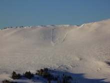
Over the past 12 hours a fast moving cold front has swept down from the north, depositing 2-3 inches of snow in the mountains around Bozeman and Big Sky. The southern ranges only picked up a trace. Winds spiked during the frontal passage, but have decreased to 5-15 mph out of the NNW. Mountain temperatures are currently in the high teens to low 20s F. Snow showers will taper off this morning and skies will become partly cloudy by this afternoon. Today, mountain temperatures will rise into the high 20s and winds will blow out of NNW at 10-20 mph.
Yesterday was a warm day with mountain temperatures reaching above freezing. Under a slight inversion, temperatures at 5 a.m. are in the high 20s as westerly winds blow 20-30 mph in the north and 10-20 mph in the southern mountains. A cold front drops in later this afternoon which will bring a small, but welcome shot of snow. I’m expecting 1-2 inches tonight as temperatures drop into the teens with west to northwest winds blowing 15-25 mph.


This morning temperatures were near 20 degrees F except near Cooke City and West Yellowstone where temperatures were near 10 degrees F. Winds this morning varied across the region blowing from all directions on the western half of the compass. At ridgetops near Bridger and Hyalite Canyon winds were blowing 20-40 mph, near Big Sky 5-15 mph, and further south near West Yellowstone and Cooke City 5-10 mph. No snow fell overnight and none is expected today which will have mostly sunny skies and temperatures approaching 32 degrees F. Westerly winds will blow 10-20 mph.
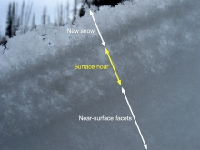
Curious why La Nina hasn’t brought more snow to SW Montana? Read a brief explanation from the National Weather Service office in Missoula here.
Yesterday another 2-3 inches of snow fell in most areas except the southern Madison Range and the mountains near West Yellowstone which only got a trace. This morning temperatures were in the teens F and ridgetop winds were blowing 10-20 mph from the WNW. In the Bridger Range ridgetop winds were blowing 35-40 mph. Today will have sunshine and temperatures in the mid to high 20s F with little change in the winds. The next chance for snow may be Sunday evening.
Curious why La Nina hasn’t brought more snow to SW Montana? Read a brief explanation from the National Weather Service office in Missoula here.

Yesterday an additional 1-2 inches of snow fell. Not much, but a little snow is better than none at all. This morning winds were blowing 15-20 mph from the SW with temperatures in the low teens F. Today will be mostly cloudy and temperatures will be in the high teens F. Winds will increase and blow 15-30 mph from the W. Late this afternoon some moisture should arrive from the north but only produce 1-2 inches of snow. Long range models indicate more snow for the rest of December. Keep your fingers crossed.
Ask and you shall receive. Four to six inches of low density snow fell in the northern mountains early this morning. The Club got four while Bridger Bowl measures six. The southern ranges got two to four inches. Winds are westerly and averaging 10-15 mph with occasional gusts to 30 mph, except on the ridge at Bridger Bowl where they are blowing 30-45 mph. Mountain temperatures are in the teens. Another inch or two will fall this morning before tapering off. This afternoon skies will turn partly cloudy and westerly winds will lessen to 10-20 mph.
Montana is officially diagnosed with PDD; Powder Deficit Disorder. La Nina is the cure, but she’s playing hard to get. We have not had snow since last Monday and there’s none forecasted in the next 24 hours. Like a pauper with cupped hands I’m hoping that Thursday will bring a few flakes. This morning mountain temperatures are in the high teens with southwest winds blowing 10-15 mph at the ridgelines. Today, morning clouds/fog will give way to mostly sunny skies with light winds.


A split jet stream is diverting active weather patterns to the north and south, leaving southwest Montana in a doughnut hole. Currently mountain temperatures are in the mid teens F and winds are blowing 5-15 mph out of the SSE under partly cloudy skies. Today, temperatures will warm into the mid 20s F and winds will shift to the SSW blowing 10-20 mph.
High pressure remains the dominant weather pattern over southwest Montana. This morning skies are clear and mountain temperatures are between 15-20⁰ F. Winds are blowing out of the WSW at 5-20 mph. Today, skies will start out clear but become partly cloudy by this afternoon. Temperatures will rise into the mid 20s to low 30s and winds remain light out of the WSW.