Avalanche Incidents
SS-AS-R1-D1-I
Elevation: 7,700
Aspect: NE
Coordinates: 45.9196, -110.9760
Caught: 0 ; Buried: 0
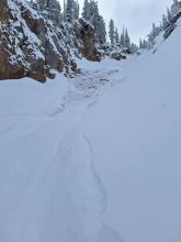
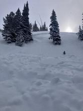
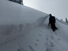
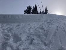
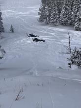
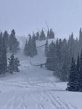
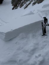
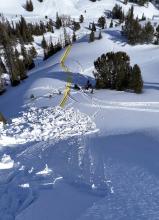
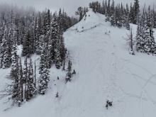
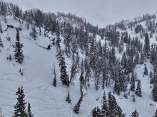
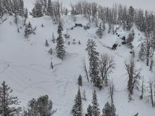
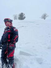
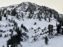
Today (Saturday, 4/19), I triggered a small soft-slab avalanche at about 7,700' on a E-NE aspect on the headwall between Frazier Lake and Angier Lake in the northern Bridgers. The slide was maybe 6" deep, 20' wide and ran 100-200 feet and involved only the new storm snow over the icy, thick crust underneath. No one was caught or injured, though I had a bit of a scare because my dog was right in the path (luckily she outran it). We had gone up with the intention of skiing the Ainger "Love Chutes", but bailed partway up when that whole aspect turned out to be breakable crust. However, we had beta from another party that conditions on the Frazier-Angier headwall were good, so decided to check that out. We skinned up without incident, following a well-set skin track that followed the line of least resistance; snow surface was variable but seemed stable. Coming down, we mostly followed the ascent route, but towards the end I was tempted onto a fun-looking, untracked stash a bit to skier's left, that seemed only a tad steeper than the ascent line. A few turns into this line is when I triggered the slide, right at the steepest part (mid-high 30s). It definitely took me by surprise given that we'd been skiing great, stable powder in the Bridgers the past couple days. No harm done but definitely a good wake-up call!
More Avalanche Details

AS-R1-D1.5
Elevation: 9,000
Aspect: E
Coordinates: 45.8926, -110.9620
Caught: 0 ; Buried: 0
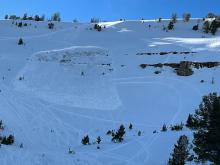
We went on a tour in the Bridgers today, we ascended the east ridge of Naya Nuki to the entrance of the Great One. Wind was blowing and we were being careful about potential wind slabs up high.
Skier 1 ski cut the top of the chute and produced a small wind slab that ran to the break in the chute and continued another 100 vert down the east apron. After all meeting up halfway down, skier 2 proceeded to ski the E facing apron. A wind slab propagated and carried skier 2 roughly 300 vert down the apron where skier 2 was able to swim out of the fall line and came to a rest on top of the debris. Everyone was okay aside two missing ski poles.
On the way out, we saw a few more small natural wind slabs that broke naturally near ridge lines as well as point and release wet slides.
More Avalanche Details

Elevation: 8,800
Aspect: E
Caught: 0 ; Buried: 0
A snowobarder tagged us in an IG story of triggering a long running, powerful wet loose slide in the Bridger Range.
More Avalanche Details
AS-R1-D1.5-I
Elevation: 9,000
Aspect: NE
Coordinates: 45.7943, -110.9360
Caught: 0 ; Buried: 0
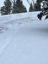
From BBSP: " At 2.45?pm a... solo skier triggered a wind loaded pocket on the main face of Saddle Peak that ran down over the cliff and produced an impressive powder cloud.... I met him... and confirm he was alone and no one was in front of him. The avalanche looked to be 2' deep on the southern flank and 5" deep on the northern flank... It entrained more snow on the way down, one 2' deep downhill wind loaded pocket and some loose wet snow. It ran into the bottom of the going home chute, gouging a large hole and then 100ft downhill left a 200ft by 30ft wide shallow debris pile."
More Avalanche Details

HS-AMu-R2-D2-O
Elevation: 8,800
Aspect: NW
Coordinates: 44.9772, -111.2860
Caught: 0 ; Buried: 0
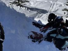
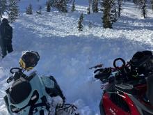
A group of riders saw Mark at the gas station and shared that they had triggered a 4' deep slide in a small pocket in Sunlight Basin of the Taylor Fork area. It was in an area with a relatively shallower snowpack, and broke on weak snow near the bottom of the snowpack. The rider that triggered it was going uphill and got stuck shortly after and noted the snowpack was much deeper there.
More Avalanche Details

SS-AS-R2-D1.5-S
Elevation: 7,500
Aspect: NE
Coordinates: 45.9278, -110.9620
Caught: 1 ; Buried: 0
From obs: "Skier triggered wind slab on Northeast slope at 7,450 feet elevation. One skier was caught and carried roughly 10 feet before the slide came to a stop."
We also received reports from another group (IG story video) that triggered a couple similar sized wind slab avalanches in north facing chutes in Frazier Basin.
More Avalanche Details
HS-AMu-R2-D2-O
Elevation: 9,100
Aspect: SE
Coordinates: 44.7250, -111.3220
Caught: 0 ; Buried: 0
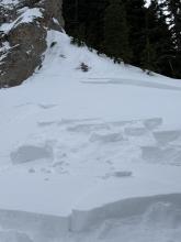
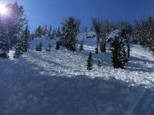
Also, on our way out we saw an avalanche in Airplane Bowl that had been triggered during the day today. This slide also broke on the persistent weak layers, 2-3' deep, 150' wide.
More Avalanche Details
HS-AMu-R4-D3-O
Elevation: 9,200
Aspect: N
Coordinates: 44.7413, -111.3740
Caught: 0 ; Buried: 0
A rider triggered a huge avalanche in the uppermost reaches of Targhee creek. We discovered it on our way out. The best we could tell looking at their tracks was that they had no idea they triggered it, even though part of their tracks were swept away.
More Avalanche Details


HS-AMu
Coordinates: 45.0465, -109.9770
Caught: 0 ; Buried: 0
We received a call (from a third party) about a snowmobiler that was buried with their head 5 feet below the snow and their foot sticking out of the snow. Their partners saw the foot and dug them out. The riders face was blue, but quickly became responsive after a "chest thump".
They were riding on the north side of Miller Mtn. Given the widespread winds and drifting, we suspect it was likely a hard wind slab avalanche similar to one spotted on Crown Butte the same day .
More Avalanche Details
SS-AMu-R1-D1-I
Elevation: 9,700
Aspect: E
Coordinates: 45.0682, -109.9570
Caught: 0 ; Buried: 0
Observed a snowmobile triggered avalanche today. East facing slope, approx 9700', between Fischer Peak and LuLu pass. Rider was not caught. HS-AMu-D1-R1-I. Observed lots of wind transport and loading from strong w/sw winds today.
More Avalanche Details

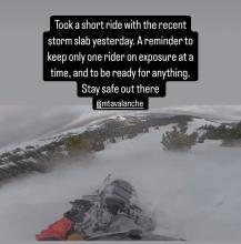
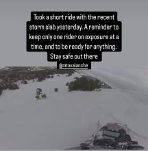
SS-AMu-R2-D2
Coordinates: 45.1719, -111.3800
Caught: 0 ; Buried: 0
From IG Message/ Stories: “Took a short ride with the recent storm slab yesterday. A good reminder to keep only one rider exposed at a time, and to be ready for anything. Stay safe out there.”
More Avalanche Details
SS-AMu-R3-D2-O
Elevation: 9,000
Coordinates: 44.9096, -111.1940
Caught: 1 ; Buried: 1
Snowmobile triggered avalanches that resulted in a partial burial with no injuries on Friday, Feb 21 and a second slide on Saturday, Feb 22 with no one caught.
More Avalanche Details

SS-AMu-R2-D2
Aspect: NE
Coordinates: 44.9041, -111.1850
Caught: 1 ; Buried: 1
From email: "One of my crew was partially buried in an avalanche today(head about 1’ down, leg and arm still above snow) at approximately 13:10 hrs. Slope was greater than 35 degrees, crown approximately 85 yards wide, over 3’ at its thickest point. I believe it was a NE exposure with wind loading at the top. I had a bad feeling about this slope and mentioned it to my crew and avoided riding on it until one rider ran out of gas and I had to help him. Upon completion of task, I rode back to a spot that wasn’t as safe a vantage point as what I had previously stayed at, but the intention was we were all on our way out. So I parked and within 30 seconds, I hear my friend yelling behind me. I turn and immediately think “oh he’s about to hit us”. So, I attempted to start up my sled, to no avail While watching behind me. Suddenly, a massive “snow cloud” appeared about 30 yards above him and it took about 2-4 seconds to register that it was an avalanche and not another rider careening out of control at us. By that time, it was too late to do anything. The avalanche had reached the back of my friend and my sled, pushing us forward about 6 feet at 3-4mph. After it stopped, I assessed 3 of four of our team was accounted for, and one (the one who yelled at us) was not. He was partially buried by the front of the avalanche much like our sleds were. Fortunately, within 5 seconds, I saw an arm and a leg sticking out of the snow and we had his airway and head cleared within about 20 seconds. He was located approximately 10 yards from us. "
More Avalanche Details
SS-AMr-R3-D2-O
Elevation: 8,000
Coordinates: 44.4780, -111.1350
Caught: 0 ; Buried: 0
From SnoWest Forums FB Page:
“Just getting word of a LARGE Remote Rider Triggered Slab Avalanche down inside of Black Canyon itself just off the Black Canyon Loop Trail in Island Park.
A 3-4ft thick slab broke loose and filled the bottom of the canyon with 12-15 FEET of debris, completely blocking off the canyon itself. Rider was NOT caught in it!! Had the rider been caught, there would have been ZERO chance of rescue under such a deep slide!”
More Avalanche Details

SS-AMu-R2-D2-S
Coordinates: 45.1719, -111.3800
Caught: 0 ; Buried: 0
Buck ridge, snowmobile triggered avalanche. Propagated storm slab.
More Avalanche Details
AMu-R1-D1
Coordinates: 44.7145, -111.3180
Caught: 0 ; Buried: 0
From FB message: "Small slide in lower elevation back by lionshead"
More Avalanche Details
SS-ASu-R1-D1.5
Aspect: NE
Coordinates: 45.7943, -110.9360
Caught: 0 ; Buried: 0
Three skiers descending the northside of Skyline Ridge on Saddle Peak triggered a wind slab avalanche that ran 400 vertical feet. No one was caught.
More Avalanche Details
SS-AS-R2-D1.5-O
Elevation: 7,200
Aspect: SW
Coordinates: 44.9842, -111.0770
Caught: 0 ; Buried: 0
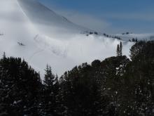
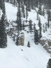
While driving to and from West Yellowstone today, I noticed what is potentially a skier/snowboarder-triggered avalanche on the east side of HWY 191 on a West/Southwesterly aspect, directly across the highway from the Bacon Rind Area and Snowslide Creek. There were numerous tracks through steep rocky chutes next to the road, one of which had avalanched perhaps 75' wide, 18-24" deep, and running nearly to the flats at the base of the slope. Judging by the thin layer of fresh snow it potentially happened on Sunday or maybe Monday. There were tracks through the cliffs above the slide and coming out of the slide.
***Attached video is from a GNFAC field work at Bacon Rind unrelated to the avalanche, but likely on the same day***
More Avalanche Details

ASu
Elevation: 7,800
Aspect: SE
Coordinates: 45.8322, -110.9280
Caught: 1 ; Buried: 0
From the phone message: A skier on the south side of Bradley's Meadow triggered an avalanche and was caught and carried by the slide. Thankfully, everyone was okay.
More Avalanche Details
AMu
Coordinates: 44.7292, -111.3230
Caught: 1 ; Buried: 0
We received a vague report of a partial burial in the Lionhead area after a snowmobiler unintentionally triggered an avalanche. The slide was reported to a homeowner near the Denny Creek trailhead. The homeowner is friends with several members of Fremont County search and rescue. One of which happened to be with GNFAC Forecasters today.
More Avalanche Details
SS-R3-D2-S
Aspect: E
Coordinates: 45.8231, -110.9260
Caught: 1 ; Buried: 1
From Bridger Bowl: "On December 15th, 2024 at 12:09 p.m., a skier in open terrain was caught and buried by an avalanche in the Papa Bear region below Bridger Gully. The skier, who was with a partner, was buried just below the snow surface and was able to punch a hole up through the top of the snow. The skier's partner and other members of the skiing public responded quickly and were able to extricate the uninjured skier.
Although rare, inbounds avalanches may happen and are defined in the skier's responsibility code as an inherent risk of skiing, even within ski area boundaries. We share this as a reminder of the importance of skiing and riding with a partner, especially in deep snow conditions."
Notes about snowpack:
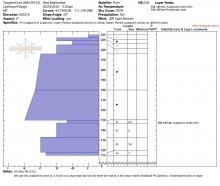
Slide was 8 inches deep, 450 feet wide, and broke within the storm snow 2 inches above the new snow/old snow interface. Trigger unknown.
The Alpine weather station received 2.5" snow = 0.2" SWE from 2200 on 12/14 to 0300 on 12/15, then intense snowfall from 0700 to 1200 added 7" and 1"SWE for a storm total of 9.5"=1.2"SWE over 14 hours as of noon.
More Avalanche Details
SS-ASu-R3-D2-S
Aspect: NE
Coordinates: 45.8822, -110.9520
Caught: 0 ; Buried: 0
From IG: "Storm slab broke about 200’ above us as skinning up the hallway coming from the north side on the throne."
More Avalanche Details
SS-ASu-R2-D1.5-I
Elevation: 9,500
Aspect: NE
Coordinates: 45.0607, -111.2720
Caught: 0 ; Buried: 0
Gusty winds transporting snow in Taylor Fork on Saturday. Triggered a 4-5 inch deep wind slab that propagated about 50 ft at the top of a north east facing slope at 9,500 ft.
More Avalanche Details
SS-ASu-R1-D1-O
Elevation: 9,200
Aspect: W
Coordinates: 45.3407, -111.3910
Caught: 0 ; Buried: 0
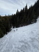
A skier near Going Home Chute in Beehive Basin triggered a small avalanche in steep terrain that broke 20 feet wide and ran 100 feet downslope over rocks.
More Avalanche Details
WL-N-R1-D1.5-U
Elevation: 7,900
Caught: 0 ; Buried: 0
From obs: "With the inversion and warmer temperatures yesterday, we (group of 3) discovered a super saturated, cohesive snowpack in Hyalite on the approach to High Fidelity. On the first pitch, I narrowly avoided a point release wet loose, probably around D1-1.5. After this we decided to bail. On the rappel, my partner narrowly avoided another wet loose, which he estimated to be D1.5 and deep enough to bury a person past their chest. The sun was not out but the mountains were shedding and there was evidence of warming and wind, because the trees had no snow on them. We were able to make ~2.5 feet in diameter “cinnamon rolls” by rolling a snowball downhill. If you’re going to any of the more exposed climbs in Hyalite, be very mindful of overhead hazards and wet loose problems which you would not expect this time of year."
More Avalanche Details
SS-ASu-R2-D2-O
Elevation: 8,100
Aspect: NE
Coordinates: 45.8156, -110.9230
Caught: 0 ; Buried: 0
From IG Message: “Hey guys - my partner broke off a small avalanche in super couloir today… broke full depth across half the couloir, 2-3’ deep/20’ wide and looked like it ran around 500’. No one was caught. He might message you with pictures too but here’s a video from the top”
From IG Message: “Skier triggered Pocket in super couloir. Wasn't very unexpected, the skiers left side felt a little slabbier than the skiers right and tried to stay off it but got blinded by a sick face shot. Triggered going over a sharky rock spot, not very fast moving and easy to ski out of. Snow depth was 2-2.5 feet”
More Avalanche Details