Good morning. This is Ian Hoyer with the Gallatin National Forest Avalanche Forecast on Friday, January 5th at 7:00 a.m. This information is sponsored by Spark R&D and Klim. This forecast does not apply to operating ski areas.
There are 2 inches of new snow this morning around Bozeman and Big Sky and a trace to 1” across the rest of the advisory area. Winds are 10-20 mph out of the west and northwest with 20-30 mph gusts. Temperatures this morning are in the teens F and will rise into the 20s today. Winds will remain moderate and westerly. Another 2-4” will fall around Big Sky and Bozeman before snowfall tapers off mid-day with a trace to 2” expected near West Yellowstone, Island Park and Cooke City.

All Regions
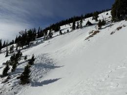
New snow is falling onto an exceptionally weak snowpack (Taylor Fork video, Bacon Rind video, Beehive Basin video). Even with just a couple inches of new snow, human triggered avalanches are possible. With widespread (now buried) surface hoar and weak facets throughout the snowpack avalanches will break wider and further above you than is typical for a new snow instability.
Today is a day of transition as we go from a dry spell into a snowy period. With this transition comes a degree of uncertainty, but there are some things we can be confident in - as soon as a slab develops, we will see avalanches. The question to focus on during your travels today is whether the new snow is thick and cohesive enough to act as a slab. Slopes that do not have a cohesive slab of new snow are unlikely to avalanche.
Today’s moderate wind speeds are perfect for drifting the new snow into deeper slabs. Look for drifts beneath ridgelines, in gullies, and behind tree islands. Keep your eyes peeled for signs of wind drifting and pay careful attention to the feel of the snow beneath your feet or machine. Be very wary of any slope that has more than 6” of new or wind drifted snow.
There is not enough new snow to cause widespread instability, rather, you’ll need to be on the lookout for pockets of instability. Renewed vigilance is required. Carefully consider the unique snowpack characteristics of each steep slope before traveling across them.
Watch for signs of instability such as cracking, collapsing, and recent avalanches and be ready to back off steep slopes if you see these signs.
The avalanche danger is MODERATE across the advisory area.
If you get out, please submit an observation. It does not need to be technical. Did you see any avalanches? How much snow is on the ground? Was the wind moving snow? Simple observations are incredibly valuable. You can also contact us by email (mtavalanche@gmail.com), phone (406-587-6984), or Instagram (#gnfacobs).
Upcoming Avalanche Education and Events
Our education calendar is full of awareness lectures and field courses. Check it out: Events and Education Calendar.
Every weekend in Cooke City: Friday at The Antlers at 7 p.m., Free Avalanche Awareness and Current Conditions talk, and Saturday from 10 a.m.-2 p.m. at Round Lake Warming Hut, Free Rescue Practice.
We offer Avalanche Fundamentals with Field Session courses targeted towards non-motorized travelers in January and one geared towards motorized users. Sign up early before they fill up.
King & Queen 2024, 3 February 2024. Form a team or sign up individually to hike laps on the Bridger Bowl ridge to fundraise for the Friends of the Avalanche Center.
Loss in the Outdoors is a support group for those affected by loss and grief related to outdoor pursuits. Check out the link for more information.
Here’s a quick read, The Invisible Hands of Avalanche Work, an interview with GNFAC forecaster, Doug Chabot.