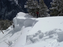
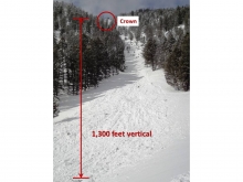
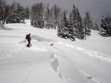
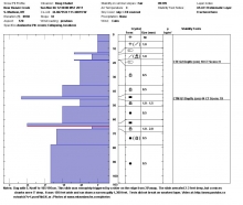
Advisory Archive
Most mountain locations picked up 1-2 inches of new snow in the last 24 hours. Winds have been calm with mountain temperatures last night dropping to 10F from yesterday’s highs in the upper 20s. Today will turn sunny before clouding up later this afternoon. Temperatures will reach the low 30s and winds will pick up from the west. Tonight snowfall will measure 2-4 inches with ridgetop winds at 20-30 mph.

Since yesterday morning 3-4 inches of snow has fallen in the Bridger Range, while a trace to 2 inches has fallen elsewhere. Mountain temperatures are ranging from 5 degrees F in Cooke City to the low teens in most other locations. Winds are fairly calm, blowing out of the WSW at 5-15 mph, with the exception of the Ridge at Bridger Bowl where they are blowing out of the SSE at 5-10 mph. Today, temperatures will warm into the low 30’s under partly cloudy skies and winds will stay light out of WSW. An increasing chance of snow will arrive tomorrow afternoon.
Since yesterday morning 3-4 inches of snow has fallen in the Bridger Range, while a trace to 2 inches has fallen elsewhere. Mountain temperatures are ranging from 5 degrees F in Cooke City to the low teens in most other locations. Winds are fairly calm, blowing out of the WSW at 5-15 mph, with the exception of the Ridge at Bridger Bowl where they are blowing out of the SSE at 5-10 mph. Today, temperatures will warm into the low 30’s under partly cloudy skies and winds will stay light out of WSW. An increasing chance of snow will arrive tomorrow afternoon.
Over 18 inches of new snow has fallen in the mountains around Cooke City since yesterday morning. The rest of our advisory area has picked up 5-7 inches. This morning mountains temperatures are ranging from the mid teens to low 20s F and winds are light out of the WSW at 5-15 mph. Today temperatures won’t get much warmer and winds will stay light out of the WSW. Another weak weather disturbance will move in by early afternoon producing light snow showers throughout southwest Montana. An additional 2-4 inches will fall around Cooke City and West Yellowstone while 1-2 inches will fall in the mountains around Big Sky and Bozeman.
Over the past 24 hours a trace to one inch of new snow has fallen over the mountains of our advisory area. Currently, winds are blowing 15-30 mph out of the WSW and temperatures are in the mid teens to low 20s F. Today, winds will gradually increase out of the WSW with ridgetop gusts reaching close to 40 mph. Temperatures will rise into the mid 20s to low 30s F under cloudy skies. An approaching storm will impact our area by late afternoon producing light mountain snow showers. 2-4 inches of snow will likely accumulate in most areas by tomorrow morning with the exception of Cooke City which will likely pick up 4-6 inches.
Since yesterday morning the mountains near Cooke City received 6 inches of snow while all other areas received 1-3 inches. Yesterday evening westerly winds increased to 20-30 mph but decreased this morning to 10-20 mph. Temperatures this morning were in the low teens F and should warm to the mid 20s F. Today will be mostly cloudy and only a trace of snow might fall by tomorrow morning. Snowfall should resume on Saturday.
The mountains near Big Sky, West Yellowstone, and Cooke City received 1-2 inches of snow since yesterday. This morning temperatures were near 20F and winds were blowing 15-20 mph from the WSW. More snow should fall today. High temperatures will be near 30F and winds will continue unchanged. By tomorrow morning most areas will receive 3-5 inches.
Yesterday was a snow free day. West winds decreased and are currently averaging 15-20 mph with gusts to 35 mph. Under partly cloudy skies the temperature dropped last night to 20F from yesterday’s high near 30F. Today will begin with mostly sunny skies, yet clouds will increase. Temperatures will climb to near freezing as winds remain west to southwest at 20 mph. Late tonight a spit of snow will drop a trace to one inch in the northern mountains and 1-2 inches in the south.
Since yesterday morning two inches of snow fell from Big Sky to West Yellowstone with Cooke City getting four inches. Mountain temperatures are in the upper teens, just a few degrees colder than yesterday’s high. Wind is the weather story. West to southwest winds started blowing yesterday morning and are averaging 25 mph with gusts to 68 mph. Mid slope anemometers are showing winds raking all elevations. These speeds will decrease to 20-30 mph later this morning. In the next 24 hours, under mostly cloudy skies mountain temperatures will climb only a few degrees with little chance of snowfall.
Over the past 24 hours 1-2 inches of new snow fell in most areas. Mountain temperatures are on the cool side ranging from the single digits to low teens F. Winds have started to pick up - blowing out of the W-SW at 15-30 mph with gusts in Hyalite and Big Sky reaching into the 40’s. Winds will continue to increase throughout the day with gusts reaching upwards of 60 mph by this afternoon. Temperatures will climb into the 20’s under mostly cloudy skies. A cold front will arrive this evening bringing with it cooler temps and light precipitation. 1-3 inches will accumulate in the mountains by tomorrow morning.