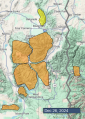
Advisory Archive
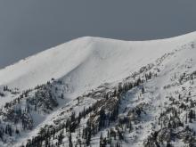
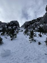
Recent snowfall - an extra inch of snow fell in most areas very early yesterday morning. It hasn’t been snowing a lot recently, but most areas south of Bozeman have picked up snow containing 0.5 inches of water over the last 7 days making the skiing and riding quite nice on slopes untouched by wind.
This morning snow is falling and ridgetop winds started increasing from the SW again at 20-30 mph gusting to 45 mostly at upper elevation ridgelines. Temperatures are in the upper teens and low 20s F. As of 6 a.m. only a trace to one inch had accumulated.
Today winds from the SW should continue to increase and blow all day. With cloudy skies and some snowfall, temperatures shouldn’t rise more than a few degrees. A heavy band of moisture rolling across the Snake River plain of Idaho will bring heavy snowfall to the Island Park area where the NWS has issued a Winter Storm Warning with 7-11 inches expected today. Most other areas to the north should get 2-4 inches today and a few more tonight.


Yesterday strong winds blew from the south 10-40 mph gusting to 60 mph at 11,000 ft.
This morning winds died off (averaging 3-10 mph from the W) and temperatures cooled considerably (mid 20s F). 3-4 inches of snow fell near Big Sky, 1-2 inches near West Yellowstone/Island Park, 1-2 inches in Hyalite, and the Bridger Range and Cooke City area remained dry.
Today a few more snowflakes could fall in the early morning hours, then skies will slowly clear and become mostly sunny. Winds will be light, and temperatures shouldn’t warm more than a few degrees. Taylor Swift’s boyfriend’s team (aka the Chiefs) will beat the Steelers but it won’t be easy overcoming the Steeler defense with Mahomes nursing a sore ankle.
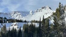
Weather through the weekend will be snowy and cool with the heaviest precip occurring this weekend and favoring southern parts of the forecast area.


This morning, temperatures are in the upper teens to mid-20s F with 10-20 mph winds from the south through the west (5-10 mph in Cooke City). In the last 24 hours, the mountains across the advisory area received a trace to 1” of new snow.
Today, temperatures will be in the 20s to upper 30s F under partly cloudy skies. Winds will blow 5-15 mph from the south and west, and 1-3” of snow tonight will make Santa feel at home. A series of storms will impact the area between Christmas and New Year’s Day, with Island Park, West Yellowstone, and Cooke City as the focal points for the most snow.
Since yesterday morning, 2” of snow fell near Cooke City with none elsewhere, and winds were out of the west and southwest at 10-25 mph with gusts of 25-45 mph. This morning temperatures are high teens to high 20s F. Today, under mostly cloudy and snowy skies, temperatures will reach high 20s to low 30s F with wind out of the west at 5-15 mph with gusts to 25 mph. Snow could be heavy as it starts, this morning in the southern mountains and in the north by this afternoon, with 1-3” possible by tonight.


This morning there is 1-2” of new snow near Bozeman, Big Sky and Cooke City. Temperatures are low 20s to 30 F. Overnight, wind from the southwest and west increased to 10-30 mph with gusts of 30-55 mph.
Today, skies will be mostly sunny near Bozeman and Big Sky with clouds and light snow elsewhere. Temperatures will be in the 20s to low 30s F with wind out of the west decreasing to 10-20 mph. Tonight cloud cover will increase throughout the forecast area with 1” of snow possible by morning and 2-4” more through tomorrow.


This morning, there is no new snow. Winds are 10-20 mph out of the west. Temperatures are a bit above freezing in the mountains around Bozeman and Big Sky and a few degrees below freezing elsewhere.
Today, temperatures will rise into the 30s and low 40s F under partly to mostly sunny skies. Winds will remain moderate, shifting to the southwest.
Tonight, there will be a few snow showers, but only a trace-1” of new snow will accumulate.

There is no new snow. This morning, winds are moderate to strong out of the south and west (a bit lighter out of the northwest in Cooke City). Temperatures are in the 20s and 30s F.
Today, skies will be clear, winds moderate out of the southwest, with high temperatures in the 30s F.
It looks like there will be a dusting of snow tomorrow night with more chances for snowfall during the next work week.


Yesterday’s strong winds from the W were like a giant hair dryer melting snow off my sidewalk. In the mountains, they created massive plumes of snow as upper elevation wind gusts hit 80 mph. Most ridges had sustained 25-40 mph winds. Mountain temperatures were in the upper 20s F while they were above freezing in the Bridger Range. Snow fell near Cooke City with maybe 0.5 inches of SWE, but it's hard to tell how much because of the strong winds.
This morning winds have shifted direction and eased. Bringing cooler air from the NW, winds are averaging 15-20 mph gusting 35-40 mph. Temperatures are mostly in the upper teens F.
Today will be a gorgeous day in the mountains with a ridge of high pressure bringing mostly sunny skies, some high level clouds this afternoon, and temperatures warming near freezing again. Winds will steadily decrease through the day. This ridge of high pressure will remain through Saturday evening when a series of troughs or storms begin rolling through the area, but no major storms and snowfall are in the forecast yet.


This morning, temperatures are in the high teens to 20s F, with 15-35 mph winds from the southwest to the west. The mountains received 1-2” of snow.
Today, the wind will increase to 20-40 mph from the west to the southwest. Temperatures will be in the high 20s to 30s F, and Cooke City will get 1-2” of additional snow, with a trace elsewhere.


Mountain temperatures are in the teens F this morning, with 10-15 mph winds from the northwest to southwest.
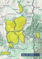
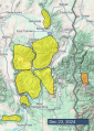
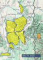
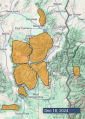
24 Hour Snowfall Totals:
- Big Sky - 7-12” (0.3-0.6” Snow water equivalent - SWE)
- Bridger Range, Cooke City, West Yellowstone, and Island Park - 4-6” (0.4-0.8” SWE)
- Northern Gallatin Range - 2” (0.2” SWE)
Today, high temperatures will be in the 20s F, with 5-10 mph winds from the west to southwest. The mountains around Cooke City, West Yellowstone and Island Park will receive an additional 2-4” of snow by tomorrow morning, with a trace to 2” near Big Sky and Bozeman.