This is Ian Hoyer with pre-season avalanche, weather and event information for the Gallatin National Forest Avalanche Center on Saturday, November 2nd. This information is sponsored by The Friends of the Avalanche Center. We will update this bulletin as conditions warrant.
Snowfall on Thursday night brought 2-3” inches of snow to the mountains near Bozeman, 5” near Big Sky, and 7-8” near West Yellowstone, Island Park and Cooke City. Winds have been out of the south and west at 10-20 mph with 30-45 mph gusts. Temperatures are in the 20s F this morning. Highs today and tomorrow will be in the 20s and 30s F. Winds will remain moderate out of the southwest today and shift more northerly tomorrow. More snow is on the way starting this afternoon or evening. It looks to favor the Island Park area where we could see 6-10” by tomorrow morning. 2-6” will fall across the rest of the advisory area. Another pulse of snow is forecasted for Monday night.
All Regions
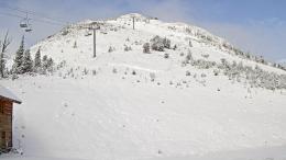
Snow is starting to pile up on some slopes at higher elevations and that means it’s time to be thinking about avalanches (webcam photos from Friday). It doesn’t matter if you’re hiking, hunting, skiing, or ice-climbing; if you’re crossing a slope with snow that’s deep enough to cover the rocks and vegetation, you may be able to trigger a slide.
A layered snowpack is needed to trigger an avalanche. This means that you should be on the lookout for slopes that help snow before this last storm or where wind has drifted the new snow into multiple layers. Higher elevations, shady slopes, gullies and slopes directly beneath ridgelines are the places where you’re more likely to find these conditions. New snow falling on dirt is less concerning.
It can be hard to turn your avalanche brain on when you’re starting out at a muddy trailhead and it’s been six months since you last thought about snow, but if you do find snow deeper than mid-calf, all the typical mid-winter travel advice applies. Everyone in your group needs avalanche rescue gear (beacon, shovel and probe). Only expose one person at a time to avalanche terrain while a partner watches from a safe spot. Watch for red flags that indicate instability, such as recent avalanche activity, cracking and collapsing. If you see these signs - avoid steep slopes.
Slopes with continuous snow cover are not only the most likely place to trigger an avalanche, but also the most attractive place to ski or ride. This is a scary combination if you’re searching out early season turns. Dig down and test the snowpack for instability before considering travel in avalanche terrain. Avalanches of wind-drifted snow will be shallow and generally small, but even small slides can injure or be fatal, especially if they drag you into rocks or trees.
If this all sounds like more work than you want to deal with in early November, don’t worry. You can keep things simple by just avoiding steep, snow covered slopes. Take the extra few minutes to walk around that drifted gully or find a windswept ridge to hike up instead of crossing that loaded bowl.
We are preparing for winter and will collect snowpack information as the snow builds up. If you have avalanche, snowpack or weather observations to share, please submit them via our website, email (mtavalanche@gmail.com), phone (406-587-6984), or Instagram (#gnfacobs).
We are preparing for winter and will collect snowpack information as the snow builds up. If you have avalanche, snowpack or weather observations to share, please submit them via our website, email (mtavalanche@gmail.com), phone (406-587-6984), or Instagram (#gnfacobs).
Upcoming Avalanche Education and Events
Our education calendar is full of awareness lectures and field courses. Check it out: Events and Education Calendar.
Friends Fall Powder Blast Fundraiser!
The Friends of GNFAC had a successful Powder Blast Fundraiser. Thank you to the sponsors, everyone who attended, bid on the silent auction or donated. We are still accepting general donations, so if you missed the party last week and want to support avalanche outreach and education you can still contribute to the fall fundraising campaign HERE.
We are preparing for winter and will collect snowpack information as the snow builds up. If you have avalanche, snowpack or weather observations to share, please submit them via our website or email mtavalanche@gmail.com.
Read accident reports from previous early season accidents before you venture to the snowy hills. This accident report from October 2012 in the northern Bridger Range, and this report from the tragic fatality six years ago in early October are reminders of the potential consequences of even a small avalanche.


