Good morning. This is Dave Zinn with the Gallatin National Forest Avalanche Forecast on Monday, April 3rd at 7:00 a.m. This information is sponsored by Blitz Motorsports and Yamaha and the Yellowstone Club Community Foundation. This forecast does not apply to operating ski areas.
The mountains around Big Sky, West Yellowstone and Cooke City received 1-3” of snow yesterday. Temperatures are in the single digits F, and winds calmed and shifted to the southwest to southeast at 5-10 mph. Today, temperatures will be in the 20s F with east to northeast winds blowing 5-15 mph. West Yellowstone will see up to 5” of snow by tomorrow morning, with a trace to 2” elsewhere.

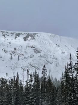
The southern ranges of the advisory area received 12-14” of snow in the last few days. Strong winds drifted snow onto slopes where avalanches breaking 1-2’ deep are likely today. Larger avalanches failing on deeply buried weak layers are possible.
Despite poor visibility, we had many reports of avalanches yesterday within the new and wind-drifted snow. Near Cooke City, a natural avalanche broke 1-3’ deep and 100’ wide on Woody Ridge (photos and details), and a skier remotely triggered a wind-loaded slope on Mineral Mountain from 20’ away that avalanched 12-18” deep, 750’ wide and ran into mature trees below (photo and details). We saw six natural avalanches in the Taylor Fork that broke within the new and wind-drifted snow above Beaver Creek (photos and details, video).
True to form this season, new snow and wind-loading resulted in at least a few deep slab avalanches. In the Hayden Creek drainage south of Cooke City, an avalanche broke 1000’ wide and 4-6’ deep (photos and details), and near Hilgard Peak in the Southern Madison Range, an avalanche similarly appeared 4-6’ deep and 1000’ wide (photos and details, video). Groups sent in two noteworthy observations of deep slab avalanches from outside the advisory area; a large avalanche in the Tobacco Root Mountains (photo) and an avalanche east of Emigrant Peak in the Absaroka Range that broke an estimated 10’ deep and 1000’ wide (photo and observation).
Recreate on slopes less than 30 degrees steepness, avoiding areas immediately below steep slopes. Choose smaller, non-wind-loaded slopes without terrain traps. The danger is CONSIDERABLE.

The northern ranges of the advisory area received 5-7” of snow and strong winds in the last few days. Avalanches breaking 1-2’ deep within recently wind-drifted snow and on deeply buried weak layers are possible.
Yesterday, groups sent in details and photos of natural avalanches breaking 1-3’ deep on wind-loaded slopes in the Bridger Range (Battle Ridge, Naya Nuki). On Friday, a natural avalanche failed on Cedar Mountain near Big Sky (photo), and a rider triggered a 2-3’ deep avalanche from 100’ away in Portal Creek (photo and details).
Recent deep slab avalanches highlight a dangerous possibility. Thursday, outside the Big Sky Resort boundary, a snowboarder took a nasty ride over cliffs in a slide that broke 2-4’ deep (photo). Earlier this weekend, an avalanche above Ainger Lake in the Bridger Range broke several feet deep and 500 feet wide, running to the Lake below (details and photos).
Dig and test for instability in the upper few feet of the snowpack and retreat from steep slopes where signs of instability are present. Choose smaller, non-wind-loaded slopes with fewer hazards, like trees or cliffs. The avalanche danger is MODERATE.
Please share avalanche, snowpack or weather observations via our website, email (mtavalanche@gmail.com), phone (406-587-6984), or Instagram (#gnfacobs).
Upcoming Avalanche Education and Events
Hyalite Canyon road is closed for motorized use until May 16.