Good morning. This is Ian Hoyer with the Gallatin National Forest Avalanche Forecast on Saturday, March 25th at 7:00 a.m. This information is sponsored by Montana State Parks and Archer Construction. This forecast does not apply to operating ski areas.
Snow totals vary widely this morning. There are 12” of new snow in Hyalite, 6-7” in the Bridgers, near Big Sky, and at Lionhead and 3-4” in the Taylor Fork and near Cooke City. Temperatures are in the single digits and teens F. North and west wind at 10-20 mph with gusts of 20-30 mph will continue today. High temperatures will be in the teens and 20s F. Snowfall will continue today and tonight with 6-10” near Bozeman and Big Sky and 3-5” near West Yellowstone and Cooke City by tomorrow morning.

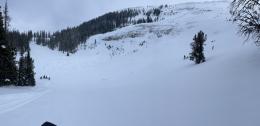
New snow, wind, and deeply buried weak layers make for dangerous avalanche conditions. Conditions are most dangerous in the places with the most new snow. The setup is right for some intense localized bursts of snowfall today - if it is snowing heavily, the danger is also spiking. Avalanches will be easily triggered anywhere the new snow has been wind drifted into deeper slabs and may also break in non-wind affected areas where snow totals are deeper. Watch for cracks shooting out in front of your skis or sled as a sign that the new snow is unstable and ready to avalanche on steep slopes.
The even more worrisome concern is that this new snow may tip the scales and cause huge avalanches to break deep in the snowpack (see yesterday’s video on Mt. Blackmore). The slide that broke 8-10 ft deep earlier this week on Elephant Mtn. (details and photos) is just the latest example of the huge avalanches that could be triggered or break naturally today. See the avalanche activity list and our recent videos for many more examples of recent big slides. These avalanches have been breaking after even small loading events. When the skies clear after this storm I expect to see evidence of some big avalanches. Stay off of and out from under all steep slopes so you don’t trigger one and aren’t hit from above when a slide breaks naturally. Keep it simple - complete avoidance is the answer today.
Human triggered avalanches are likely and the avalanche danger is CONSIDERABLE.

There is less new snow in Cooke City and less is expected today. Our concerns are the same as elsewhere, but new snow slides will be smaller and deep slabs are a little less likely. In no way does this mean conditions are safe. On Thursday, a slide near Daisy Pass broke 4 ft deep and 150 ft wide, catching two snowmobilers and breaking one of their femur’s (details and photos, video). Similar slides are possible today. Avoiding steep slopes entirely is a reasonable strategy. If you are going to poke onto slopes steeper than 30 degrees choose smaller slopes with clean runouts (no trees or gullies beneath you) that haven’t been recently wind-loaded.
Large human triggered avalanches are possible and the avalanche danger is MODERATE.
Please share avalanche, snowpack or weather observations via our website, email (mtavalanche@gmail.com), phone (406-587-6984), or Instagram (#gnfacobs).
Upcoming Avalanche Education and Events
Our education calendar is full of awareness lectures and field courses. Check it out: Events and Education Calendar.
Sunday, March 26, Avalanche Alliance Sweepstakes! Win a custom 2022 Ford 350 Super-Duty truck or many other items. Proceeds help support avalanche centers. Use code LASTCHANCE to receive 40% more tickets. Winners will be chosen at the Jackson Hole Hill Climb.
Loss in the Outdoors is a support group for those affected by grief and loss related to outdoor pursuits. Check out the link for more information.
On Wednesday, March 22nd, a snowmobiler was killed in an avalanche in central Idaho. This brings the total number of avalanche fatalities in March to 7 people across the U.S.
More info on each event is available at the Avalanche.org Accidents Page.