Good morning. This is Doug Chabot with the Gallatin National Forest Avalanche Forecast on Thursday, March 16th at 6:45 a.m. This information is sponsored by Yellowstone Club Community Foundation and Montana State Parks. This forecast does not apply to operating ski areas.
Since yesterday morning the mountains around Bozeman and Big Sky got hit with 11-14” of snow while in Taylor Fork, around West Yellowstone and Cooke City, 6” fell. Wind is currently W-NW at 10-15 mph with an occasional gust of 25 mph and temperatures are in the single digits F. Skies will clear today and temperatures will rise into the low 20’s F as west wind becomes light at 10-15 mph. A lingering mountain shower may drop a trace to 1” this morning before high pressure and sunny skies dominate through Sunday.
The Avalanche Warning has expired for the southern mountains. The storm began late Monday and dropped 2-3 feet of snow (2-2.5” snow water equivalent) with strong westerly wind. This new snow will create avalanches, but deeply buried weak layers could create even bigger slides; either would be deadly. Dave and Ian rode into Tepee Basin in the southern Madison Range and found 2 feet of new snow and saw a avalanches that had broken during the storm (video, observation). They even saw a couple avalanches near Bacon Rind on the drive home (photo).
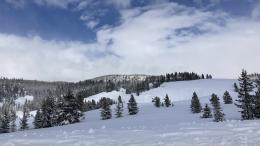
Today will become sunny and calm. It will be a great day to be in the mountains, but also a dangerous one. The snowpack needs time to adjust to its new load and will be sensitive to triggering today. We cannot rush Mother Nature. Staying off of slopes steeper than 30-degrees (avalanche terrain) is a given, yet we also need to stay away from flatter terrain at the bottom of slopes so we do not get buried from above. Sunny skies embolden us, but the snowpack doesn’t care.
The avalanche danger is rated CONSIDERABLE on all slopes.
The Bridger Range, Hyalite and Big Sky area picked up 11-14” of snow in a surprisingly robust storm. This snow added .8-1.5” of SWE to the snowpack, a fair bit of weight. As Ian noted in our video from Buck Ridge on Tuesday, even a little snow is concerning because weak layers 3-5 feet deep could avalanche on a few slopes. Yesterday’s storm was a wallop to the snowpack and we need to travel cautiously by avoiding avalanche terrain. Cornices along ridgelines will be touchy and could trigger slopes below. Furthermore, a person could trigger an avalanche in the new snow which could then trigger a deeper avalanche. The mechanics are not important, just that dangerous avalanche conditions exist. Sunny skies are sirens calling you forth, only to dash your well laid plans in an avalanche.
The avalanche danger is rated CONSIDERABLE since triggering a slide is likely.
Please share avalanche, snowpack or weather observations via our website, email (mtavalanche@gmail.com), phone (406-587-6984), or Instagram (#gnfacobs).

The Avalanche Warning has expired for the southern mountains. The storm began late Monday and dropped 2-3 feet of snow with strong westerly wind. This new snow will create avalanches, but deeply buried weak layers could create even bigger slides; either would be deadly. The snowpack needs time to adjust to its new load and will be sensitive to triggering today. Staying off of slopes steeper than 30-degrees (avalanche terrain) is a given, yet we also need to stay away from flatter terrain at the bottom of slopes so we do not get buried from above.
Upcoming Avalanche Education and Events
Our education calendar is full of awareness lectures and field courses. Check it out: Events and Education Calendar.
Saturday, 10 a.m. - 2:00 p.m. Avalanche Rescue Training, drop in for any amount of time. Round Lake Warming Hut, Cooke City. Free.
Sunday, March 26, Avalanche Alliance Sweepstakes! Win a custom 2022 Ford 350 Super-Duty truck or many other items. Proceeds help support avalanche centers. Use code LASTCHANCE to receive 40% more tickets. Winners will be chosen at the Jackson Hole Hill Climb.
Loss in the Outdoors is a support group for those affected by grief and loss related to outdoor pursuits. Check out the link for more information.
A list of all avalanche activity from our forecast area is available HERE.