Good morning. This is Ian Hoyer with the Gallatin National Forest Avalanche Forecast on Saturday, March 11th at 7:00 a.m. This information is sponsored by Bridger Bowl, Cooke City Motorsports and Community Food Co-op. This forecast does not apply to operating ski areas.
There are 3-4” of dense new snow in the mountains near Bozeman and 5-7” near Big Sky, West Yellowstone and Cooke City. Winds are 20-30 mph out of the west-northwest with gusts of 45-60 mph this morning. Yesterday afternoon gusts over 100 mph were recorded at Lionhead and on the summit of Lone Mountain. Temperatures are single digits and teens F. High temperatures will be in the teens and 20s F under partly sunny skies. Strong west winds will continue today, but gusts will not be as extreme as yesterday. An inch or two of snow are possible tonight in Cooke City. Other areas will only get a few flurries.

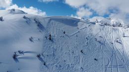
Avalanches are likely within the newly wind drifted snow and also possible on deeply buried weak layers. 5-7” of dense new snow has drifted into much thicker cohesive slabs that will be easily triggered today and will break plenty deep to bury you. Hurricane force winds will have built drifts in unusual places. With such strong winds it may be hard to identify which slopes are loaded and which are just wind affected.
Simply avoid steep slopes altogether to avoid the possibility of triggering a huge, unsurvivable slide breaking deep in the snowpack. With incremental loading last week avalanches were triggered on weak layers buried in early January (Cooke City video). I’m very worried about people triggering similar slides today. Don’t try to outsmart the snowpack or thread the needle near questionable terrain. Give the persistent weak layers time to adjust to this load by sticking to slopes less than 30 degrees and staying way out from under them as well. Large, human triggered avalanches are likely and the avalanche danger is CONSIDERABLE.

Less snow fell around Bozeman, but very strong winds still blew that new snow into drifts sitting on top of persistent weak layers. Last week, large, deep avalanches were triggered after a very moderate loading event (Hyalite video). Similar slides are possible today and with a bit of loading are somewhat more likely today than they were yesterday.
If the potential for deep slab avalanches isn’t keeping you out of avalanche terrain entirely today, be on the lookout for wind drifts and dig to test for recently buried weak layers in the upper snowpack. Expect wind drifts in unusual places at low elevations and far below ridgelines. Cracks shooting out in front of your skis or sled are clear signs that you’ve found an unstable drift that would avalanche on a steep slope.
Avalanche danger is MODERATE.
Please share avalanche, snowpack or weather observations via our website, email (mtavalanche@gmail.com), phone (406-587-6984), or Instagram (#gnfacobs).

Heavy snowfall and strong winds yesterday makes for dangerous avalanche conditions today. There are ~18” of storm snow that could avalanche by itself (deeper in drifts) and slides could also break deeper in the snowpack. Decision making is simple today - simply avoid steep slopes and give them a wide berth if you’re traveling beneath them. See Dave’s video update from yesterday for more travel advice.
Upcoming Avalanche Education and Events
Our education calendar is full of awareness lectures and field courses. Check it out: Events and Education Calendar.
Every Saturday, 10 a.m. - 2:00 p.m. Avalanche Rescue Training, drop in for any amount of time. Round Lake Warming Hut, Cooke City. Free.
Loss in the Outdoors is a support group for those affected by grief and loss related to outdoor pursuits. Check out the link for more information.
A list of all avalanche activity from our forecast area can be viewed HERE.