Good morning. This is Ian Hoyer with the Gallatin National Forest Avalanche Forecast on Saturday, February 11th at 7:00 a.m. This information is sponsored by Bridger Bowl, Cooke City Motorsports and Chad Bunting-Financial Advisor-Edward Jones. This forecast does not apply to operating ski areas.
This morning, there is no new snow. Winds are 10-20 mph out of the southwest and west. Temperatures are in the teens and 20s F. Moderate winds will continue today with temperatures rising to the high 20s and 30s F under mostly sunny skies. The next chance for snow is on Monday night.

All Regions
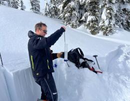
You can trigger large avalanches today on weak layers loaded by snowfall and wind earlier this week. Windloaded slopes remain the likeliest places to trigger slides. The wind drifts themselves have had a bit of time to bond, but they are sitting on weak layers throughout the snowpack that will stabilize more slowly. There are layers of surface hoar and near surface facets in the upper 3-4 ft of the snowpack and also weak snow near the ground (Hyalite video, Buck Ridge video). The last human triggered avalanche was reported in Tepee Basin on Thursday (observation), with more slides breaking earlier in the week (avalanche log). Signs of instability are getting fewer and further between. This is a positive trend, but it means that you need to be more active in searching for instability before riding steep slopes. The best way to do this is to dig down to look for and test the buried weak layers (Taylor Fork video). Keep it simple: if you get propagating results in an Extended Column Test, stick to lower angle slopes for the day.
Remember that tracks on a slope don’t mean it won’t avalanche, only that no one has hit just the wrong spot yet. If you’re going to ride steep slopes make sure that you’re carrying an avalanche beacon, shovel, and probe and have a partner watching from a safe spot.
We got reports of the snow surface becoming wet on some sunny slopes yesterday afternoon, but not enough to cause a real wet snow hazard. Expect the same again today.
The avalanche danger is rated MODERATE across the advisory area.
Please share avalanche, snowpack or weather observations via our website, email (mtavalanche@gmail.com), phone (406-587-6984), or Instagram (#gnfacobs).
Upcoming Avalanche Education and Events
Our education calendar is full of awareness lectures and field courses. Check it out: Events and Education Calendar.
February 16, FREE Avalanche Awareness night for women at REI Bozeman. Time TBD.
February 19, 10 a.m.-2p.m. Companion Rescue Clinic Field Day in the Bozeman area. Required Online Classroom Session at 6 p.m. on Feb 18. Information and course registration are HERE.
March 3-5, Bozeman Splitfest. More info and register here.
Every Saturday, 10 a.m. - 2:00 p.m. Avalanche Rescue Training, drop in for any amount of time. Round Lake Warming Hut, Cooke City. Free.
Loss in the Outdoors, is a support group for those who have been affected by grief and loss related to outdoor pursuits. Check out the link for more information.
Bruce Jamieson’s videos on Snow Science explain heady topics to the layman. Understanding the avalanche dragon helps keep us alive.