Good morning. This is Ian Hoyer with the Gallatin National Forest Avalanche Forecast on Friday, December 16th at 7:00 a.m. This information is sponsored by Blitz Motorsports and Yamaha and Uphill Pursuits. This forecast does not apply to operating ski areas.
Please consider donating to the Friends of GNFAC Annual Fundraiser.
In the mountains around Bozeman and Big Sky, 6-10” of snow fell since yesterday morning. Near West Yellowstone and Cooke City, only a trace to 3” fell. Winds are 10-20 mph out of the north and west with gusts of 25-40 mph. Temperatures are in the single digits F. Today will be partly sunny with highs in the teens F. Winds will continue out of the north and west at 10-20 mph. No new snow is expected.
On wind-loaded slopes, avalanches will be easily triggered in fresh wind drifts, up to 4 ft deep. 48 hour snow totals are adding up to 14-18”. Be aware that you might find less new snow in some areas as snowfall appears to be patchy with some weather stations reporting almost no new snow. Look and feel for wind drifts before getting on steep slopes. Steer clear of pillows of drifted snow that have formed beneath ridgelines or in cross-loaded gullies. Feel for the snow stiffening beneath your skis or sled as a sign you’ve found a drift and look for cracks shooting out in front of you as a clear sign that the drift is unstable.
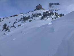
Also be on the lookout for weak layers deeper in the snowpack. Yesterday, Doug and I found a dramatic layer of weak, sugary facets at Buck Ridge (video). We’re not sure how widespread these weak layers are around Bozeman and Big Sky, but Dave also found them on Mt. Ellis on Monday (video). This uncertainty should give you pause, even on non-windloaded slopes.
Human triggered avalanches are likely and the avalanche danger is CONSIDERABLE on wind-loaded slopes today. The danger is MODERATE on all other slopes.

Avalanches could break today on weak layers in the lower snowpack. Yesterday, riders north of Cooke City saw evidence of two large, recent avalanches (details). These avalanches may be triggered from the flats beneath a steeper slope (observation). Obvious signs of instability might not present themselves today, but the weak snow structure is widespread, so plan to give yourself a large margin of safety. Slopes with wind drifts are more likely to break on these deep weak layers and also have thicker slabs which will allow avalanches to break wider. For today, avalanches remain possible and the danger is rated MODERATE.
If you get out, please share avalanche, snowpack or weather observations via our website, email (mtavalanche@gmail.com), phone (406-587-6984), or Instagram (#gnfacobs).
Upcoming Avalanche Education and Events
Our education calendar is full of awareness lectures and field courses. Check it out: Events and Education Calendar.
TOMORROW, Thursday, December 15, 6:30 p.m., 1-Hour Avalanche Awareness at Uphill Pursuits. Free.
Saturday, December 17, 10 a.m., Avalanche Awareness - Winter Wonderland at Montana Science Center. More information HERE.
Monday, December 19, 5:30 p.m., Women in the Backcountry at MAP Brewing. Free.
Every Saturday, 10 a.m - 2:00 p.m. Avalanche Rescue Training, drop in for any amount of time. Round Lake Warming Hut, Cooke City. Free.
Send us your observations. They do not have to be fancy, just a few sentences. Did you see any avalanches? How much new snow? Is the wind blowing and drifting snow? Pictures, snowpits and stability test scores are also welcome, but not necessary. You can help us fill in the gaps of our field work.