Good morning. This is Dave Zinn with the Gallatin National Forest Avalanche Forecast on Tuesday, December 13th at 7:00 a.m. This information is sponsored by Alpine Orthopedics & Sports Medicine, Knoff Group Real Estate and Werner Wealth Management (Advisors with DA Davidson). This forecast does not apply to operating ski areas.
Please consider donating to the Friends of GNFAC Annual Fundraiser.
This morning, mountain temperatures are around 10 degrees F with 5 to 10 mph winds from the east to the north. One to three inches of new snow fell across the advisory area. Today, temperatures will be in the upper teens to low 20s F with 5 to 10 mph winds from the north to the west. Light snowfall will return to the area on Wednesday.

A persistent weak layer of sugary facets is buried 2-3 feet deep on many slopes around Cooke City and West Yellowstone and in the Southern Madison and Southern Gallatin Ranges. Natural and human-triggered avalanches have failed up to 6 feet deep on wind-loaded slopes on this weak layer within the last week (Avalanche Activity List).
Natural avalanches are unlikely today, but human-triggered avalanches are a dangerous possibility. Tracks on a slope do not indicate stability, and skiers or riders can trigger slopes from the flats below steep slopes, as Alex and his partner learned firsthand near Cooke City last Friday (video, photo).
While digging and performing a stability test can help us identify instability, the safest management strategy for large avalanches breaking on persistent weak layers is avoiding avalanche terrain and the runout zones below. While we know these weak layers are not on every slope, trying to outsmart the instability is a gamble with serious consequences.
Today, large human-triggered avalanches are possible, and avalanche danger is MODERATE.
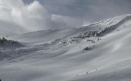
In the mountains around Bozeman and Big Sky, human-triggered avalanches are possible on slopes loaded with drifts of snow by recent winds. Avalanches on Buck Ridge, in the Northern Bridger Range and on Mt. Blackmore are indicators of this instability. While slides like the ones in the Northern Bridgers and on Mount Blackmore are relatively small (6-10” deep), they are dangerous, especially when combined with terrain traps like trees, cliffs or rocks.
Some slopes have a weak layer of facets below the wind-drifted snow. Sunday on Saddle Peak, Alex found hard slabs of wind-drifted snow sitting on top of weak facets. This is a dangerous setup for now and later in the season (video). While ice-climbing in Hyalite late last week, Doug noted a 10” thick drift was sitting on a thin layer of weak facets (Hyalite gullies video). The presence of weak layers means slopes stabilize more slowly, and avalanches could propagate across larger areas.
Not all slopes have the ingredients for an avalanche (a slab over a weak layer). Yesterday, I found a generally stable snowpack on a tour to Mount Ellis (video). This means you have homework. Dig down to look for a sugary layer of faceted snow. Assess for instabilities with an extended column test before considering skiing or riding in avalanche terrain (ECT informational video).
The avalanche danger is MODERATE.
If you get out, please share avalanche, snowpack or weather observations via our website, email (mtavalanche@gmail.com), phone (406-587-6984), or Instagram (#gnfacobs).

The mountains in Island Park have received over 2 feet of snow since Friday morning. Strong winds this weekend created drifts up to 4 feet deep. Avalanches failing within the recent and wind-drifted snow are possible today. Ian and I found a weak layer of facets buried 2-3 feet deep at lower elevations while riding in the Yale Creek Drainage on Friday (field video). Minimize your exposure to wind-loaded slopes and dig down 3-4 feet to look for a weak layer of sugary facets that makes larger avalanches possible.
Submit your snow, avalanche and weather observations to contribute to the Island Park Trip Planning page.
Upcoming Avalanche Education and Events
Our education calendar is full of awareness lectures and field courses. Check it out: Events and Education Calendar.
TONIGHT, Tuesday, December 13, 6 p.m., Avalanche Awareness + Beacons at Story Mill Park. Free.
Thursday, December 15, 6:30 p.m., 1-Hour Avalanche Awareness at Uphill Pursuits. Free.
Saturday, December 17, 10 a.m., Avalanche Awareness - Winter Wonderland at Montana Science Center. More information HERE.
Monday, December 19, 5:30 p.m., Women in the Backcountry at MAP Brewing. Free.
Every Saturday, 10 a.m - 2:00 p.m., Avalanche Rescue Training, drop in for any amount of time. Round Lake Warming Hut, Cooke City. Free.
Watch our playlist of YouTube videos to get caught up on our avalanche concerns this season.